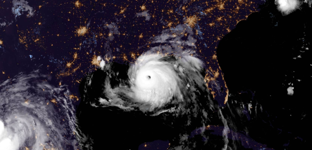
Hurricane Ida has rapidly intensfied overnight into a powerful Category 4 hurricane, with winds of 140mph. It’s set to make landfall in Louisiana in the later part of August 29th.
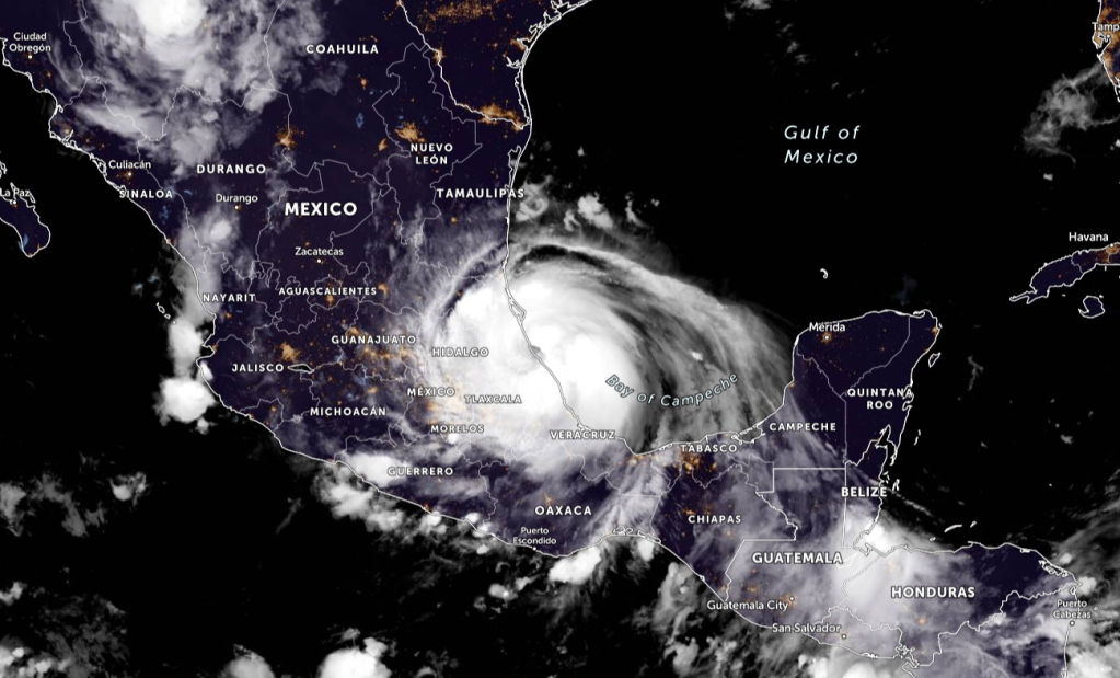
The center of Hurricane Ida was located near latitude 28.0 North, longitude 89.1 West. Ida is moving toward the northwest near 15 mph (24 km/h), and this general motion should continue through tonight and early Monday, followed by a slower northward motion on Monday afternoon. A northeastward turn is forecast by Monday night. On the forecast track, the center of Ida will continue moving across the north-central Gulf of Mexico this morning, and make landfall along the coast of southeastern Louisiana within the hurricane warning area this afternoon or evening. Ida is then forecast to move well inland over portions of Louisiana and western Mississippi on Monday and Monday night.
Key Messages:
- There is a danger of life-threatening storm surge inundation
Sunday along the coasts of Louisiana, Mississippi, and Alabama
within the Storm Surge Warning area. Extremely life-threatening
inundation of 9 feet or greater above ground level is possible
somewhere within the area from Morgan City, Louisiana, to the coast
of Mississippi. Overtopping of local levees outside of the Hurricane
and Storm Damage Risk Reduction System is possible where local
inundation values may be higher. Interests throughout the warning
area should follow any advice given by local officials. - Ida is expected to be an extremely dangerous major hurricane when
it reaches the coast of southeastern Louisiana. Hurricane-force
winds are expected Sunday in portions of the Hurricane Warning area
along the Louisiana coast, including metropolitan New Orleans, with
potentially catastrophic wind damage possible where the core of Ida
moves onshore. Actions to protect life and property should be rushed
to completion in the warning area. - Damaging winds, especially in gusts, will spread inland near the
track of the center of Ida across portions of southeastern Louisiana
and southwestern Mississippi Sunday night and early Monday. These
winds will likely lead to widespread tree damage and power outages. - Ida will produce heavy rainfall today through Monday across the
central Gulf Coast from southeastern Louisiana, coastal Mississippi,
to far southwestern Alabama resulting in considerable to
life-threatening flash and urban flooding and significant riverine
flooding impacts. As Ida moves inland, significant flooding impacts
are possible across portions of the Lower Mississippi, Tennessee,
and Ohio Valleys through Wednesday.

FORECAST POSITIONS AND MAX WINDS
INIT 29/0900Z 28.0N 89.1W 120 KT 140 MPH
12H 29/1800Z 29.1N 90.3W 125 KT 145 MPH…NEAR SERN LOUISIANA
24H 30/0600Z 30.6N 91.1W 70 KT 80 MPH…INLAND
36H 30/1800Z 32.2N 91.0W 45 KT 50 MPH…INLAND
48H 31/0600Z 33.8N 90.0W 30 KT 35 MPH…INLAND
60H 31/1800Z 35.4N 87.9W 25 KT 30 MPH…INLAND
72H 01/0600Z 36.7N 85.2W 20 KT 25 MPH…INLAND
96H 02/0600Z 38.9N 78.9W 20 KT 25 MPH…POST-TROP/INLAND
120H 03/0600Z…DISSIPATED
WATCHES AND WARNINGS
A Storm Surge Warning is in effect for…
- East of Rockefeller Wildlife Refuge Louisiana to the
Alabama/Florida border - Vermilion Bay, Lake Borgne, Lake Pontchartrain, Lake Maurepas,
and Mobile Bay
A Hurricane Warning is in effect for…
- Intracoastal City Louisiana to the Mouth of the Pearl River
- Lake Pontchartrain, Lake Maurepas, and Metropolitan New Orleans
A Tropical Storm Warning is in effect for…
- Cameron Louisiana to west of Intracoastal City Louisiana
- Mouth of the Pearl River to the Alabama/Florida border
A Storm Surge Warning means there is a danger of life-threatening inundation, from rising water moving inland from the coastline, during the next 36 hours in the indicated locations. For a depiction of areas at risk, please see the National Weather Service Storm Surge Watch/Warning Graphic, available at hurricanes.gov. This is a life-threatening situation. Persons located within these areas should take all necessary actions to protect life and property from rising water and the potential for other dangerous conditions. Promptly follow evacuation and other instructions from local officials.
A Hurricane Warning means that hurricane conditions are expected somewhere within the warning area within the next 6 to 12 hours. Preparations to protect life and property should be rushed to
completion.
A Tropical Storm Warning means that tropical storm conditions are expected somewhere within the warning area, in this case within the next 12 to 24 hours.
For storm information specific to your area, including possible inland watches and warnings, please monitor products issued by your local National Weather Service forecast office.


Leave a comment